As part of a drive to make Google Maps more useful during emergency situations, the Mountain View, California-based company is making it simpler to locate the most up-to-date information regarding wildfires.
After launching a tool in late 2019 to help people track wildfires, Google has now added a new wildfire layer to its Google Maps, which users will be able to turn on and off to see the most up-to-date information on several wildfires at once.
“Just tap on a fire to see available links to resources from local governments, such as emergency websites, phone numbers for help and information, and evacuation details,” reads Google’s blog post about the new feature. “When available, you can also see important details about the fire, such as its containment, how many acres have burned, and when all this information was last reported.”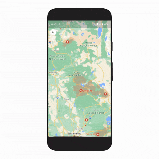
According to Google, the new wildfire tracking feature will roll out globally this week for Google Maps on Android, with iOS and desktop updates coming in October.
Further, Google states that the new feature will be expanded to cover additional fires and information regarding fires in the United States, courtesy of data from the National Interagency Fire Center (NIFC), with Australia following suit. Hopefully, a similar tie-up with the Canadian Interagency Forest Fire Centre (CIFFC) will result in Canadians getting the expanded feature as well, considering there are about 140 active wildfires in Canada right now.
CIFFC also has an interactive map of ‘Out of Control,’ ‘Being Held,’ and ‘Under Control’ wildfires, which you can check here.
Image credit: Google
Source: Google
MobileSyrup may earn a commission from purchases made via our links, which helps fund the journalism we provide free on our website. These links do not influence our editorial content. Support us here.
